🌿 Life
Look for birds, plants, insects, mammals, species observations, air-quality stations, and natural events connected to the area.
🧭 Wanderloop by Atlasemoji
Wanderloop is a geographic time machine and field guide. Pick a spot on Earth and begin looking for wildlife observations, environmental events, historical places, old photographs, public archives, geographic names, and scientific research connected to it.
✨ Some places are overflowing with digital treasures. Others are still uncharted territory. Both can teach us something.
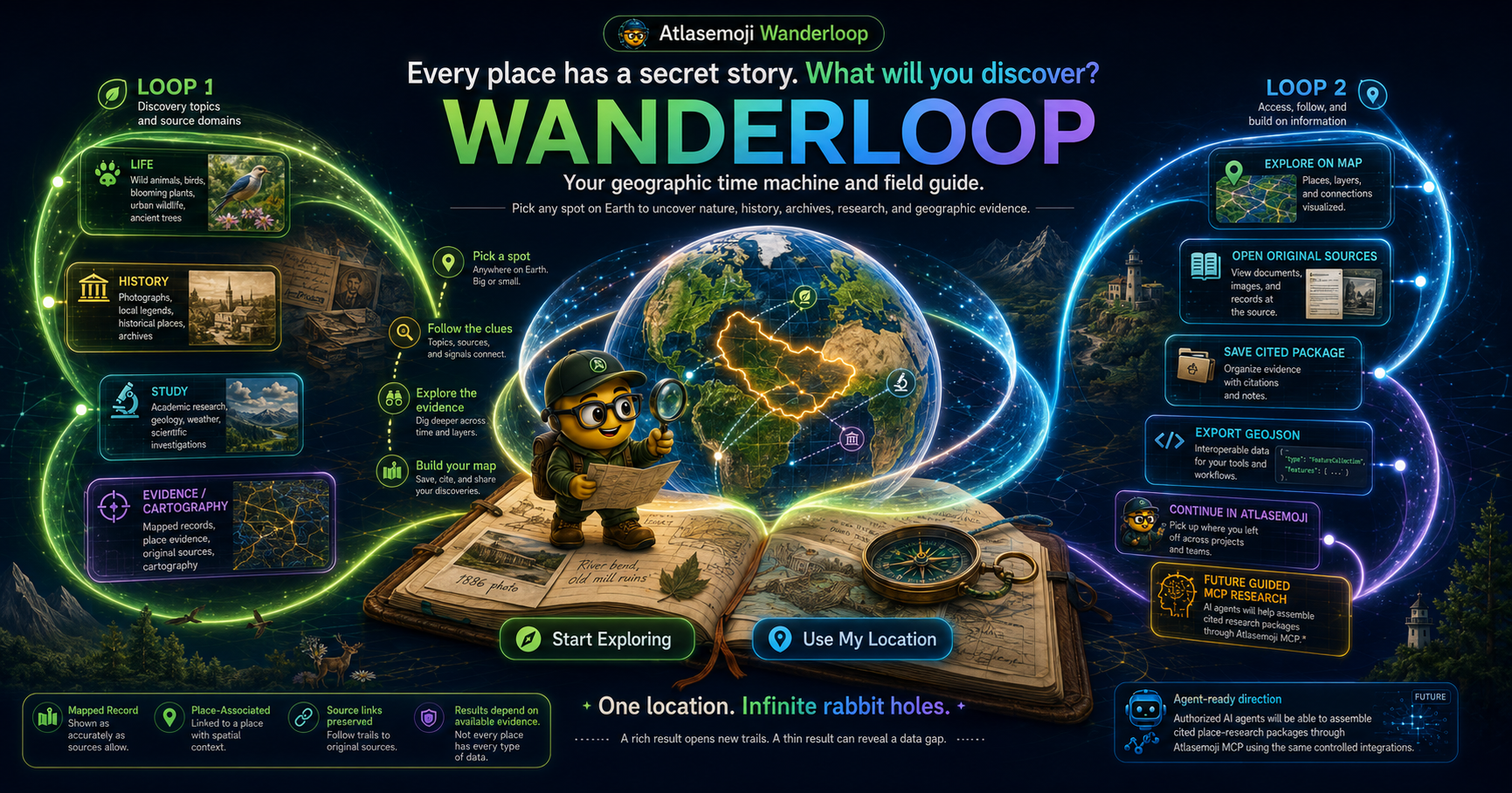
Wanderloop does not pretend that one search engine or one database knows everything. We connect approved sources that each see the world differently, preserve where the evidence came from, and bring the useful geographic pieces together.
Look for birds, plants, insects, mammals, species observations, air-quality stations, and natural events connected to the area.
Explore named places, historic sites, photographs, maps, public collections, cultural records, and archival clues.
Find academic work, researchers, institutions, gazetteers, and geographic scholarship that can help explain a place.
See which findings have verified coordinates, which are associated with the broader place, and where to open the original source.
🔌 Why these sources matter
Wanderloop integrates—or is working toward responsible integration—with organizations whose records can add real geographic context. Availability varies by provider, location, credentials, licensing, and the maturity of each connector.
Community natural-history observations
Helps reveal plants, animals, fungi, insects, and other living things observed by people in the field.
Global biodiversity occurrence records
Adds specimen and species-occurrence evidence contributed by museums, scientific institutions, and biodiversity programs around the world.
Bird conservation and observation context
Bird records can reveal migration, habitat, seasonality, and environmental change. Access may depend on the available Audubon data service.
Air-quality measurements
Connects places to environmental monitoring stations and measurements that help describe the air people and wildlife experience.
Natural events observed by Earth science programs
Can connect a place to wildfires, storms, volcanoes, floods, sea and lake ice, dust events, and other significant natural phenomena.
Structured knowledge about places and entities
Provides identifiers and relationships among places, people, events, buildings, organizations, cultural sites, and other geographic subjects.
Openly licensed photographs, maps, and media
Can show how a place looks, how it has changed, and which visual records are available for further study or citation.
Digitized books, media, websites, and historical material
Offers paths into older publications, local histories, scanned documents, audio, video, and preserved digital material.
Maps, photographs, manuscripts, newspapers, and collections
Can connect American places to authoritative historical maps, images, government records, cultural collections, and primary-source material.
Scholarly works, authors, institutions, and topics
Helps identify academic research associated with a region, subject, institution, field site, or geographic question.
Persistent researcher identities
Can help distinguish researchers with similar names and connect scholarship to the people producing it.
Historical place names and geographic relationships
Helps follow places across changing names, boundaries, languages, time periods, and historical sources.
Linked historical and cultural data
Represents an important direction for connecting historical places, people, events, collections, and research without flattening their relationships.
Represent one of these sources, know a better source, or need your service added, corrected, or removed?
💬 Contact Atlasemoji🔎 Geographic detective mode
Search your neighborhood, a national park, a landmark, a university, an ancient ruin, an industrial site, or a far-off island.
Wanderloop queries eligible providers and keeps their records separated, attributed, and connected to their original source pages.
Switch between map and list views. Filter by Life, Record, Study, or an individual provider. Open the original evidence when something catches your attention.
Save useful findings as a cited research package or GeoJSON-compatible geographic data for mapping, reports, analysis, and other Atlasemoji workflows.
A discovery tool should encourage curiosity without making the map lie. Wanderloop distinguishes exact geographic evidence from broader associations and reports the results actually delivered.
The provider supplied usable coordinates, and the point passed the selected geographic boundary check.
The record is meaningfully connected to the place, but Wanderloop does not have defensible coordinates for an exact map pin.
The number of records the provider actually delivered in this request—not a claim about every record the provider may hold.
The selected city, park, region, bounding box, or fallback radius used to limit mapped results.
Digital coverage is uneven. London, Bellevue, the Grand Canyon, a rural county, and a small island may have very different records available through the providers currently connected to Wanderloop. Provider query methods, place boundaries, access limits, source coverage, and connector maturity all affect what appears.
Caching can make a repeated search faster, but it should not invent or permanently enrich the underlying source data. A previously searched place may respond more quickly because Wanderloop can reuse fresh provider results. The number and quality of records should still come from the connected sources and the selected geographic rules.
Yes—the Wanderloop client includes a mobile results sheet and Map/List switching. On a phone, the map remains available while an expandable sheet holds the place summary, topic filters, providers, and result cards.
Map view shows verified geographic records and the selected search zone.
List view makes titles, dates, summaries, scientific names, images, and source links easier to browse.
The bottom sheet keeps discoveries close without permanently covering the entire map.
🚀 From discovery to useful geography
Wanderloop is being shaped so useful evidence can move into the rest of Atlasemoji while preserving source identity and geographic context.
Prepare mapped findings for other GIS tools, reports, analysis, or location-aware applications.
Bring selected geography into a workspace where it can be reviewed, adjusted, combined with other layers, and presented on a map.
Use approved provider connections and Atlasemoji APIs to move geographic evidence into additional workflows.
The next phase is controlled agent access so an authorized AI agent can request a cited place-research package through the same provider registry. This direction does not mean unrestricted web browsing or unrestricted provider access.
Museums, universities, scientific organizations, environmental groups, archives, public agencies, geographic projects, local historians, and community researchers may all hold valuable place-based information. We are interested in integrations that preserve attribution, source identity, licensing requirements, and geographic meaning.
💬 Contact AtlasemojiTry your neighborhood, a volcano, a shipwreck coast, a university, a battlefield, a national park, or somewhere you have only dreamed of visiting. A rich result may open a trail you never expected. A thin result may reveal a genuine data gap waiting to be mapped.
🧭 Open Wanderloop